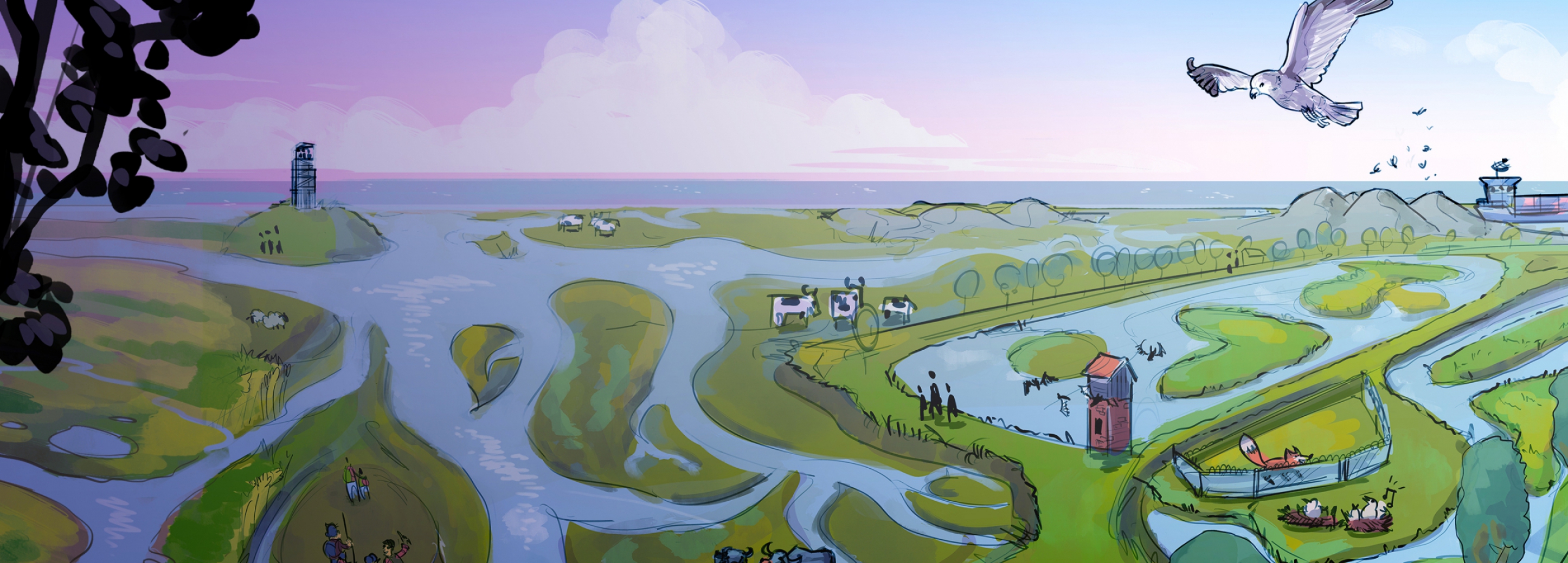
Sandwiched between the Schelde river, the Antwerp harbor and the Flemish hinterland, lies Grenspark Groot Saeftinghe. The implementation of the Hedwige-Prosper project created a 'new' area. This offers unique opportunities for nature, biodiversity, recreation and agriculture.
Because Grenspark Groot Saeftinghe is more than a nature reserve in the shadow of the Antwerp harbour all opportunities and possibilities to put this border region on the map are seized. We were asked to help clarify a future vision for the area.

Integrated and sustainable vision for the future
The border park offers space for nature, agriculture and harbour. Not just next to each other, but preferably in harmony with each other. And with all those different players (nature managers, farmers, policy makers, governments and representatives from the port), there was a need for an integrated vision for the future. With space for recreation and industry, but also including research for new, more sustainable agricultural methods.
To make those beautiful words a little more concrete, we made clear and appealing visualisations together with all those different people involved.
Interactive

Brown Harrier Project: in search of more biodiversity
In the Grenspark there are a lot of of experiments with measures that stimulate biodiversity. To help regular agriculture with this, the Brown Harrier Project has been started. Choosing suitable crops and ‘new’ sowing methods provides a friendly habitat for animals such as the Marsh Harrier.
In order to inform and enthuse farmers and policymakers in the region, they wanted to incorporate all valuable tips into a visual plan for the future.

Co-creation with different regional stakeholders
In recent months we have been busy mapping and visualizing all the topics, themes and players in the area. We did this together with farmers, regional officers, nature managers, the Province of Zeeland and the EGTC, a partner from Flanders.
That required several sessions and a lot of time, because it is still quite a challenge to get many parties to the table at the same time. But because we were all working from home this year, it was actually quite easy in online sessions.

Our visual ensures that the bundle of information and various initiatives come together. It inspires to look at the area with different eyes, to see what is behind it and which special partnerships have made the Grenspark possible.
In addition to the visualization itself, the mutual exchange and conversation between all parties is also a great yield! The Grenspark offers a participation platform where people come into dialogue with each other. Working together pays off so much!

An interactive visualisation
Result: the visualization inspires and activates!
The interactive visualization is a very large puzzle to see everything in the area. Great for the visitor of the Grenspark to dive into and discover all kinds of things about the area. At the same time, it inspires all stakeholders and interested parties to envision possibilities and partnerships. This is the effect of visualization: a powerful way to clarify a complex plan, make it concrete and actively involve people.
The regional stakeholders are enthusiastic about the end result: all the complexity comes together in one image. And they are excited that the area is so recognizable: the drawings are surely a representation of their own region!
Visual end result
This is how the visualizations come together- Previous
- Next


Discover all details
Govert van der Heijden
Curious about how we can map the future vision of your environment in an inspiring way?
Please contact Govert!
Email
Other Flatland Cases

NLWorks - Explaining a corporate story clearly with animations
Developing visuals forces you to get to the essence of your corporate story. "Now I finally understand what you are doing!"

ProRail - Environment, assets and importance clarified
For this complex operational organization, we clarified all activities, environments and assets. Drawings put departments on the map!

TU Delft - Visualising for Global Drinking Water
TU Delft supports research projects in the field of water supply. With drawings we make issues and results clear and concrete!